Index of photo albums
-- randallg's homepage
-- Kat Kam
If you got here from a search engine and you do not see the photo index frame on the left,
click here
.
Comments and questions to randallg@telemark.net
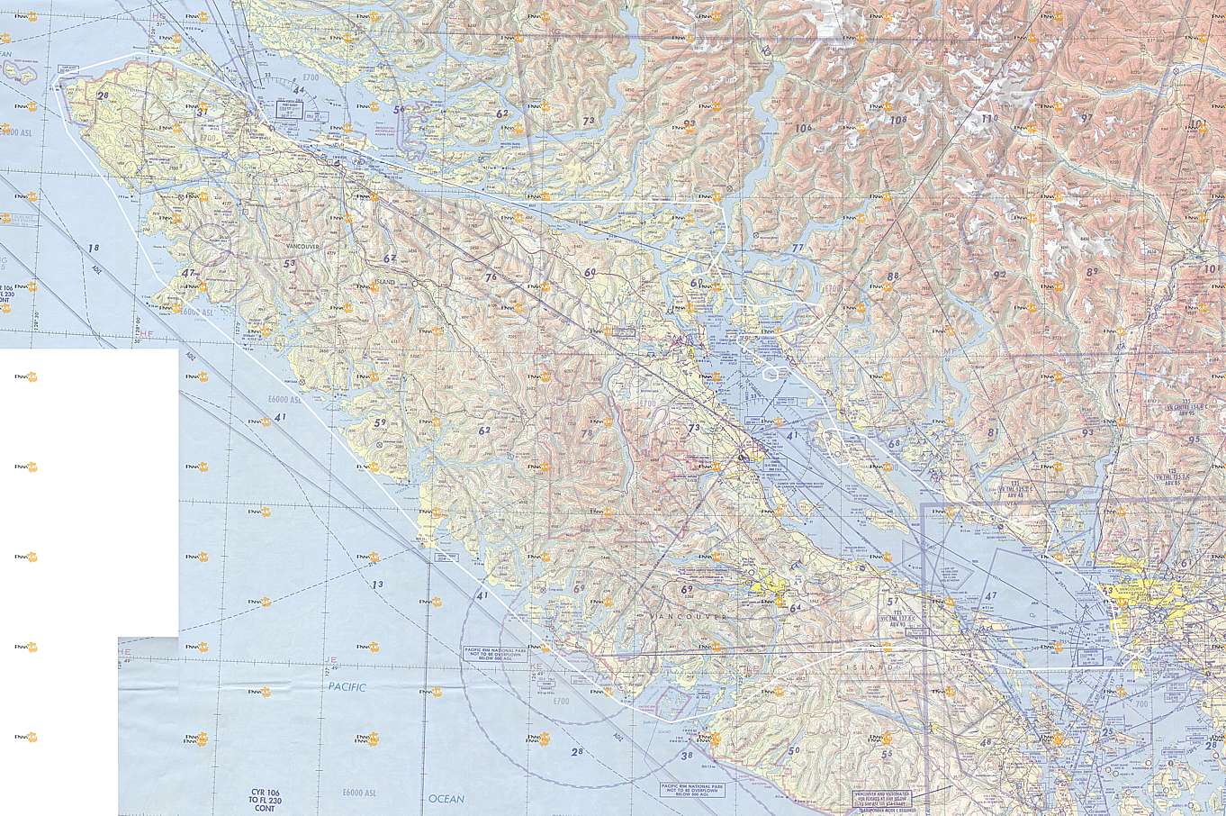
This flight was from Boundary Bay airport (near Vancouver) to Port Hardy and back. It was a beautiful fall weekend. The route was from Boundary Bay direct to Barkley Sound and Tofino, then up the west coast of Vancouver Island to Cape Scott, and around the tip to Port Hardy. The following day we flew back to Vancouver by the more direct route of the Inside Passage and the northern Gulf Islands.
This page is best viewed at a resolution of at least 1600x1200 and with a fast Internet connection. The photos are at a native resolution of 1280x960, but they will resize to the size of your browser window. You may find it convenient to open the photos in a separate browser window - click your right mouse button and select "Open Link in New Window."
Piloting by Randall. Photography by Kat.
- 001 - 002 Crossing Georgia Strait
- 003 - 010 Crossing Vancouver Island direct from Nanaimo to Barkley Sound
- 009 - Mt Arrowsmith from the south
- 011 - 013 Mouth of Alberni Inlet
- 014 - 016 Barkley Sound and the Broken Islands
- 017 - 021 Ucluelet
- 022 - Florencia Bay and Kennedy Lake in the background
- 023 - 027 Pacific Rim National Park and Long Beach
- 026 - Tofino Airport
- 028 - 036 Esowista Peninsula - Tofino is at the end of it - behind is Clayoquot Sound and Meares Island
- 034 - The Wickanninnish Inn is on the rocky point
- 037 - 038 Vargas Island
- 039 - 041 Flores Island
- 042 - 043 Sharp Point and Shelter Inlet
- 044 - 047 Hesquiat Harbour
- 048 - 050 Between Estevan Point and Nootka Sound
- 051 - 054 Nootka Sound
- 055 - 061 Nootka Island and Crawfish Lake - there is an abandoned aerodrome on the south side of Crawfish Lake
- 062 - Nuchatlitz Inlet
- 063 - Esperanza Inlet
- 064 - 067 Tatchu Point - there is an abandoned aerodrome called Port Eliza on the flat area near the river
- 068 - 072 Kyuquot Sound
- 073 - 079 Approaching Brooks Peninsula from the south - this was an amazing sight of an incredibly remote place
- 080 - 084 South side of Brooks Peninsula
- 085 - 091 North side of Brooks Peninsula
- 092 - Heater Point on Brooks Bay
- 093 - 096 Quatsino Sound - Charlotte Strait is coming into view on the other side of the mountains
- 097 - Radar Station at CFB Holberg
- 098 - 98 Raft Cove just west of the town of Holberg
- 100 - 102 San Josef Bay at the south edge of Cape Scott Provincial Park
- 103 - 106 Cape Scott Park
- 107 - 120 A series of views of Cape Scott as we rounded the northwest corner of Vancouver Island
- 121 - Fogbank over open ocean to the north
- 123 - 132 Northern edge of Vancouver Island - a very bleak place
- 135 - 139 Approach and landing at Port Hardy
- 140 - 156 Various views of Port Hardy - there was some serious fog in the morning and we did not know if we could take off
- 157 - 163 At the airport the fog was hovering just offshore
- 164 - 177 As we take off northwards on runway 29 and swing around to the south you can see the fog almost over the airport
- 181 - Port McNeill airport
- 182 - 187 Alert Bay on Cormorant Island
- 188 - Telegraph Bay
- 189 - 196 Broughton Archipelago
- 197 - 204 Mt Waddington in the distance - tallest mountain in BC
- 205 - 218 Surreal images of the Inside Passage
- 219 - 222 Estero Peak near the mouth of Bute Inlet - we flew around it
- 230 -
236 Stuart Island - you can see the marinas at Big Bay - also note the paved private airstrip which does not appear
in any aeronautical chart or publication - it is part of some rich guy's private development which includes homes and a 9 hole golf course
More info: http://www.waggonerguide.com/swigard.html
http://realestate.escapeartist.com/P-26466
- 237 - 238 From Stuart Island looking up Bute Inlet
- 239 - 251 We circled over the Octopus Islands area
- 246 - Nice shot of Octopus Islands and Hole In The Wall
- 252 - 257 Squirrel Cove on Cortes Island - the larger water is Desolation Sound
- 258 - 262 East Redonda Island - West Redonda Island is in the foreground with Waddington Channel in between - Toba Inlet is in the background
- 262 - Closeup of Pendrell Sound, surrounded by East Redonda Island
- 263 - 266 Prideaux Haven on Desolation Sound is the most famous of the anchorages - we circled over the area
- 267 - 269 Mountains to the east of Prideaux Haven and Homfray Channel
- 270 - Looking south from Prideaux Haven is Powell Lake
- 273 - 276 Prideaux Haven again this time from the south
- 277 - East Redonda Island with Waddington Channel, Pendrell Sound and Toba Inlet in the distance
- 278 - 280 Northern Cortes Island featuring Squirrel Cove from the south
- 281 - 282 Gorge Harbour on west Cortes Island
- 283 - Shark Spit on Marina Island points to Cortes Island
- 284 - Gorge Harbour
- 285 - 286 This is the south end of Cortes Island which features a small aerodrome called Hansen Airfield
- 287 - 294 We circled over Savary Island
- 295 - Powell River pulp mill - the breakwater is made out of old World War II Victory Ships
- 296 - 299 We make a loop over Texada Island to get views of the aerodrome there - this is from the south of Gillies Bay
- 299 - Vananda
- 300 - 302 Mt Elphinstone from the west and north
- 303 - 306 Familiar territory over Howe Sound
- 307 - Approach and landing at Boundary Bay
Here is a map of the route. Click here for a much larger detailed map.