Index of photo albums
-- randallg's homepage
-- Kat Kam
If you got here from a search engine and you do not see the photo index frame on the left,
click here
.
Comments and questions to randallg@telemark.net
We planned a three day flight to Revelstoke and surrounding area for the solstice weekend of 2004, and the Mountain Blues Festival. Unfortunately the Friday we planned to leave, there was a chain of thunderstorms stretching from Kamloops south into the US, blocking the direct route, and moving west towards Vancouver. We took off Friday afternoon hoping to go north via Whistler and Lillooet to Kamloops and avoid the storm line. By the time we got to Whistler the turbulence was getting intense and we could not see through the clouds ahead, so we turned back. We landed back at Boundary Bay just before some freaky high winds swept through the Fraser Valley - there was a small almost-tornado in Maple Ridge that caused some propery damage.
The next day conditions were much improved and we had a marvellous flight. We diverted south through Manning Park (to the consternation of flight following - they wondered if I knew where I was...) Then we went north to Princeton and east to Okanagan Lake near Summerland. We wanted to view the areas around Kelowna that were burned in the great fires of August 2003. There was lots of devastation and we viewed the Myra Canyon area where most of the cool train trestles were destroyed. Proceeding north we passed Vernon and Mabel Lake.
The Blues Festival that night wasn't as interesting as the previous year. Oh well. On Sunday we flew back via Shuswap Lake and Kamloops, intending to take the Lillooet/Whistler route. There was a big forest fire near Lillooet so we headed south down the Fraser Canyon. A little south of Lytton we were away from the smoke and clouds, and I was able to make a beeline for Vancouver and cross the mountains and the north end of Harrison Lake. We enjoyed a perfectly smooth and cloudless flight at 10500 feet. ATC asked me to descend quickly because he wanted me below 3000 feet at Fort Langley. Didn't want me to hit a jet or something.
This page is best viewed at a resolution of at least 1600x1200 and with a fast Internet connection. The photos are at a native resolution of 1280x960, but they will resize to the size of your browser window. You may find it convenient to open the photos in a separate browser window - click your right mouse button and select "Open Link in New Window."
Piloting by Randall. Photography by Kat.
- 001 - You can see the weather coming in from the east
- 002 - 011 - Heading up Indian Arm about as far as Mt Garibaldi, where we turned around
- 011 - Mt Garibaldi
- 012 - This bit of bluster was south of the airport as we were about to land
- 014 - 016 - The next day we are heading east to Hope - this is the Lillooet fire way in the distance to the north
- 017 - The Three Brothers alpine area in Manning Park
- 018 - 019 - the big open pit copper mine south of Princeton
- 020 - Town of Princeton where the Tulameen meets the Similkameen - the town airport is to the left
- 021 - Just north of Princeton you can make out the Jura Loop section of the Kettle Valley Railroad
- 023 - 024 - View southeast down the Similkameen Valley
- 025 - 028 - We break into the Okanagan Valley at Summerland
- 029 - 032 - Circling Okanagan Mountain Park - this is where a lot of fires were raging
- 033 - 037 - This neighbourhood south of Kelowna is where a lot of homes were destroyed by fire
- 038 - Kelowna from the south
- 039 - 054 - Circling over the Myra Canyon section of the Kettle Valley Railroad - most of the wooden trestles were destroyed
- 055 - Kelowna from the east
- 056 - 059 - Kelowna airport
- 060 - 061 - Lake Okanagan Resort on the west side of the lake
- 062 - 063 - East side of Lake Okanagan north of Kelowna
- 064 - 069 - Various views of Vernon
- 070 - 073 - Silver Star ski area northeast of Vernon
- 074 - 077 - Mabel Lake
- 075 - There is a private grass airstrip here at Mabel Lake Resort
- 078 - 083 - Mt MacPherson southeast of Revelstoke
- 084 - 099 - Descending over Revelstoke and surrounding environs in the Columbia River valley
- 094 - The Revelstoke ball park where the Mountain Blues Festival is held
- 100 - The wonderful Revelstoke Flying Club's courtesy car
- 103 - 114 - Hillcrest Resort near Revelstoke and the Mountain Blues Festival
- 115 - 116 - Back at the airport
- 117 - 119 - Revelstoke Dam and the reservoir behind it
- 120 - 134 - Between Revelstoke and Shuswap Lake
- 135 - 141 - Shuswap Lake
- 138 - I believe this is the abandoned aerodrome called Anglemont on the chart, on the north shore of Shuswap Lake
- 139 - 140 - Blind Bay on Shuswap Lake
- 143 - 147 - Along the South Thompson River
- 148 - 152 - Kamloops
- 156 - Ashcroft on the Thompson River
- 157 - 162 - As we went over the ridge towards Lillooet we came closer to the big fire - I decided the area was not passable
- 163 - Mountains near Lillooet as we turned south
- 164 - 167 - I believe this is the Stein River valley but I could be wrong
- 168 - 170 - South of Lytton the weather cleared and we turned over the mountains to head strait for Vancouver
- 171 - North end of Harrison Lake
- 174 - 183 - The north end of Stave Lake is coming into view
- 185 - Mt Baker
- 188 - Airport varmint
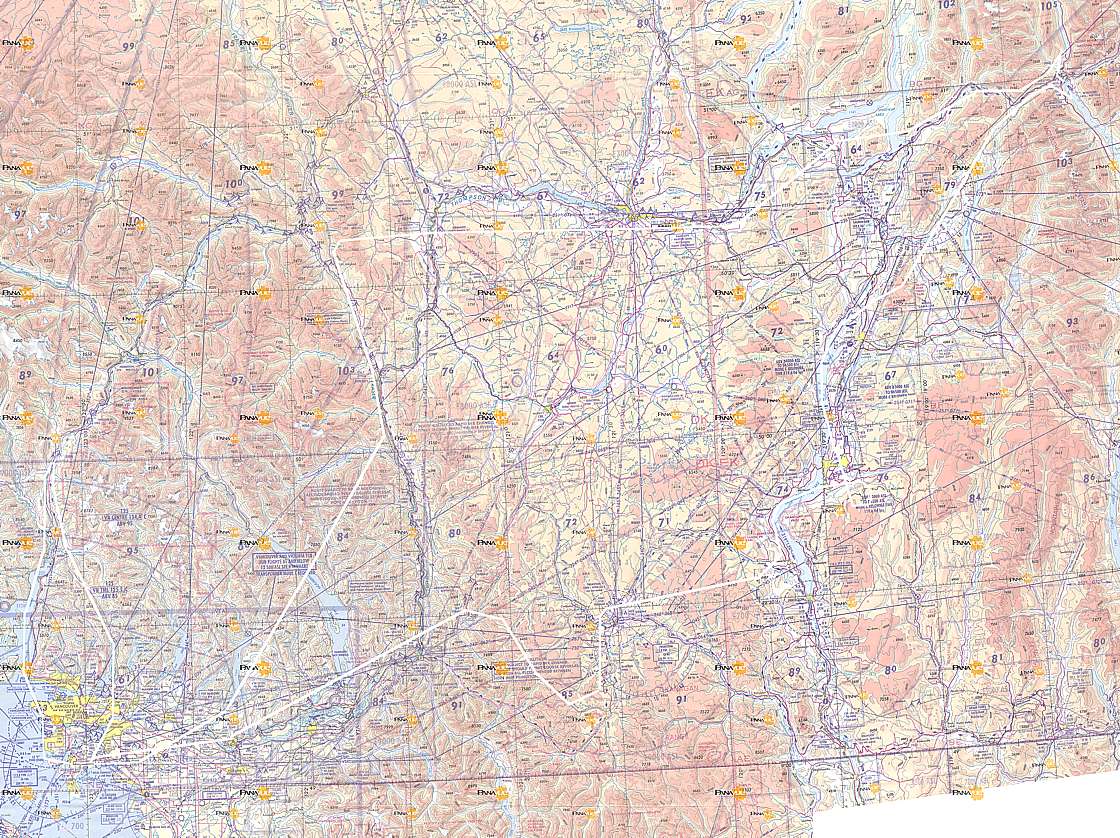
Here is a map of the route. Click here for a much larger detailed map.
Here is a map of the route. Click here for a much larger detailed map.