Index of photo albums
-- randallg's homepage
-- Kat Kam
If you got here from a search engine and you do not see the photo index frame on the left,
click here
.
Comments and questions to randallg@telemark.net
This is the log of a flight made from Boundary Bay airport near Vancouver, north to the Southern Chilcotin Mountains and the Lillooet area, and back. Vancouver had a spectacular run of good weather this fall, and this flight was made on a perfect day with not a cloud in the sky. Unusually for November, there was no fresh snow on most of the mountains, due to almost no precipitation for weeks. So the air was clear and crisp, and the autumn colours brought the scenery even more alive than usual. Enjoy!
This page is best viewed at a resolution of at least 1600x1200 and with a fast Internet connection. The photos are at a native resolution of 1280x960, but they will resize to the size of your browser window. You may find it convenient to open the photos in a separate browser window - click your right mouse button and select "Open Link in New Window."
Piloting by Randall. Photography by Kat.
- 001 - 005 - Airport Hazards
- 007 - Heading north up Indian Arm
- 010 - I didn't know about this gorgeous little lake - it's not far uphill from logging roads, about 2.5 miles south of Mt Meslilloet
- 015 - Mt Meslilloet
- 016 - Sky Pilot Mt
- 017 - Mamquam Valley east of Squamish has had most of its trees removed
- 019 - South of Paul Ridge looking north - Mt Garibaldi on the left, Garibaldi Neve in the centre
- 020 - Mt Garibaldi on the left, Castle Towers on the right, the Gargoyles and Little Diamond Head in the foreground
- 021 - Looking east up the Mamquam Valley
- 023 - Getting closer to Mt Garibaldi with Little Diamond Head in the centre
- 029 - Abeam Mt Garibaldi
- 030 - From Northwest of Mt Garibaldi, you can see the Neve behind it, the Sharkfin is the lower, pointy peak to the left of Garibaldi accross the ice
- 032 - Nice view of Garibaldi and the Neve from the north
- 033 - In the moraine of the Neve rises the Table, a flat topped volcanic neck - Glass Tiger once did a music video from on top of it
- 037 - The sublimely beautiful Lake Garibaldi - Mt Price in the foreground, Castle Towers behind
- 039 - Looking back to Mt Garibaldi
- 041 - Lake Garibaldi - the backcountry campsite is on the shore near the little islands
- 042 - North of Lake Garibaldi - Panorama Ridge is on the right with Gentian Ridge and Castle Towers behind - in the centre are the Black Tusk meadows - the dark lake is Black Tusk Lake and the green lake to the left is Helm Lake - the Cinder Code rises behind Helm Lake - Black Tusk rises to the left where you can't see it in this photo
- 045 - 050 - some shots as we buzz the Black Tusk
- 051 - The view from the Black Tusk but about 2000 ft higher
- 053 - Looking south all the way to Howe Sound
- 056 - Crossing over Singing Pass to the east of Whistler Mt
- 058 - South of Blackcomb Mt
- 061 - Over Pemberton looking down the Lillooet River
- 063 - 065 - Heading Northwest up the Lillooet River from Pemberton, these are the mountains to the south and the Pemberton Icefield
- 066 - Turning North up the Hurley Pass, this is Tenquille Lake - it's a very nice hike into this area from the Hurley Road
- 068 - 070 - Mountains to the east of the Hurley River, just north of Tenquille Lake - 68-69 are the mountain directly north of Tenquille Lake - you can see the lake in 68. It has no name on my topo. 70 is Sun God Mt. We did not follow Railroad Pass which is where the road goes - we followed the next valley to the east of Railroad Pass and joined the Hurley River about 10km north of the summit of Railroad Pass
- 070 - Sun God Mt
- 071 - 076 - and to the west of the Hurley River
- 072 - the valley in the left background is the Hurley River where it turns west from the road. The U shaped valley is a tributary of the Hurley which flows down from Mt Samson. The headwaters of Lone Goat Creek is the smaller valley to the right of the icefields. The picture was taken from near the confluence of Lone Goat Creek and the Hurley River
- 073 - Looking SE from just north of the confluence of Lone Goat Creek and the Hurley River. The basin in the centre is unnamed but the creek on the left is Waterfalls Creek
- 074 - The peak in foreground, with the tarn in front of it, is Mt Sloan. The tarn is on Ault Creek. The u-shaped valley in the left background is Lone Goat Creek, which is a large tributary of the Hurley that frames the western edge of the Sloan Range
- 077 - 078 - the old mining ghost town of Bralorne
- 079 - Downton Lake - the triangular peak at right is Mt Dickson
- 080 - Gun Lake and the Southern Chilcotin Mountains
- 081 - These are the mountains to the east of Gold Bridge - the tiny settlement in front of the peaks is Brexton, on the Bralorne-Gold Bridge Road. The craggy ridge just behind and to its right is the Kingdome, otherwise known as the Brexton Dome; the lake just below it is Kingdome Lake. The pond near Brexton is Sucker Lake. Back in my 4wd days I had a dream of finding a route to those mining tracks in the alpine. The peak-ridge straight up from that is Mt. Truax, just behind it is Mt. Williams, the gnarly one behind that is Mt. Bobb; all of these are in the Bendor Range. The peaks of the Shulaps Range are in the background-left
- 082 - Gold Bridge
- 083 - 085 - looking back to Downton Lake area - the haze is from controlled burns (I think they were controlled...)
- 086 - We are following Gun Creek to the NW - this is facing N up Eldorado Creek - the sunny ridge is the unnamed 7160' peak between Eldorado Creek and Gun Creek
- 087 - 088 - Facing NE up the entire Eldorado Creek watershed - to the far right is Big Dog Mt and even farther near the centre is Red Mt
- 089 - Facing East the centre left peak is the unnamed 7220' peak just west of the Eldorado Creek valley - to the upper right is the unnamed 7450' peak - and behind it is Eldorado Creek - to the upper left is the unnamed creek that flows west into Gun Creek
- 090 - 091 - Facing West from Spruce Lake - the valley at left is Slim Creek, the Leckie Range and Scherle Peak are in the centre, centre-right is Leckie Creek, and to its right is the unnamed range between Leckie Creek and Gun Creek
- 092 - 096 - Looking further up Gun Creek, we turn north towards Spruce Lake - in this area around Spruce Lake, Tyaughton Creek runs Southeast, then turns East to join Relay Creek. - 92 - facing WNW from Spruce Lake up Gun Creek, that is Hummingbird Lake and further upstream is Trigger Lake. Further upstream and to the right is Warner Peak. On the far right is Tyaughton Creek and the highest point in the foreground, between Gun and Tyaughton Creeks, is Mount Sheba.
- 093 - 094 - Looking northwest from near Spruce Lake, facing NW, Mt Sheba in the centre, and Tyaughton Creek watershed to the right
- 095 - Now we are proceeding east along Tyaughton Creek - this is looking south at the north side of the Eldorado Range - in the centre left is the unnamed 7970' peak - right behind that peak is the Eldorado Creek watershed - the open area in the distance is the Bridge River Valley where Gold Bridge is
- 096 - From just west of the confluence of Tyaughton and Relay Creeks, this is facing Northwest up the range between those two creeks (neither creek is visible here). The high point of the ridge in the upper centre is Cardtable Mountain, and the higher peak behind it is Relay Mountain. Between those peaks is Paradise Creek which joins Relay Creek to the right
- 097 - Crossing Relay Creek we are proceeding northeast towards Red Mt - this is the the spine of the Shulaps Range; the area in the foreground is that of Buck and Quartz Mtns, which are more plateau summits than actual peaks; the round-flat knolls in the foreground in front of Shulaps Peak are Big Dog and Big Sheep Mtns. Mud Creek is in the foreground.
- 098 - Looking SE at the Shulaps Range and Big Dog Mt. Poison Mt is just out of shot to the left
- 099 - 101 - facing SWS to Poison Mt - you can see the old mining road that winds around it on the right - and you can 4 wheel drive right to the top of it
- 102 - 108 - Heading southeast from Poison Mt we follow the Yalakom River Valley to Lillooet - more of Shulaps Ridge between the Yalakom River and Carpenter Lake - 108 is looking SW at Big Dog Mt - I have driven up the mining road on the ridge to the left and hiked to the top
- 103 - Looking SW up Blue Creek. To the lower right is the mining road which ascends the ridge to the SE of Big Dog Mt. This photo is the area north of Shulaps Peak and south of Big Dog Mt
- 104 - 105 - Looking W, Big Dog Mt is the peak on the right. Again you can see the mining road in the middle, and Blue Creek is on the left
- 106 - 107 - Big Dog Mt is out of view just to the right - you can still see the mining road on the right. Below the mining road is Blue Creek, the valley in the centre is unnamed. Shulaps Peak is just out of shot to the left
- 108 - just right of centre is the unnamed 9230' peak. The valley on the left which includes the little lake is >Peridotite Creek. The little spike above the ridge to the upper left, near the edge of the photo, is Shulaps Peak
- 109 - 116 - Approaching Lillooet we turn south and southwest into the sun - these are facing SW over Mission Ridge, towards Anderson Lake in the distance
- 111 - 112, 114 - the lake visible is Anderson Lake, identified by the knoll breaking up the reflected sun in certain images; this knoll is between D'Arcy and McGillivary Falls, which lies on the near side of the knoll
- 113 - We are near Lillooet, looking SW over the east end of Mission Ridge. Behind it is Seton Lake, and on the other side of the lake to the right of centre is the Cayoosh Canyon where the Duffey Lake Road runs
- 114 - 115 - Looking West from the east end of Seton Lake, we are following the Duffey Lake Road south. The lake is Seton Lake. In 115 you barely see Anderson Lake in the haze, and you can see the knoll previously mentioned on the west side of Anderson Lake
- 116 - Downton Creek Valley to the west of the Duffey Lake Road, in the Cayoosh Range - this looked like a natural fire
- 117 - 118 - Looking NW over the Cayoosh Range from Duffey Lake over the headwaters of Common Johnny Creek, which flows into Haylmore Creek, and ultimately joins Gates River just south of D'Arcy and flows into Anderson Lake - the mining road is on the topo
- 119 - Looking North over Mt Rohr in the foreground, which is 4km due west of Duffey Lake. The valley behind is Haylmore Creek flowing NEN - then where it joins Common Johnny Creek it changes direction to NWN
- 120 - 122 - Matier Glacier, with Joffre Peak on the left, Mount Matier in the middle, and Slalok Mt to the right - you can see Upper Joffre Lake in the foreground of 122 - We turned southwest to follow the Duffey Lake Road - most of the way home was into the sun so we didn't get any more pictures
- 123 - 124 - Howe Sound
- 126 - 130 - Downtown Vancouver
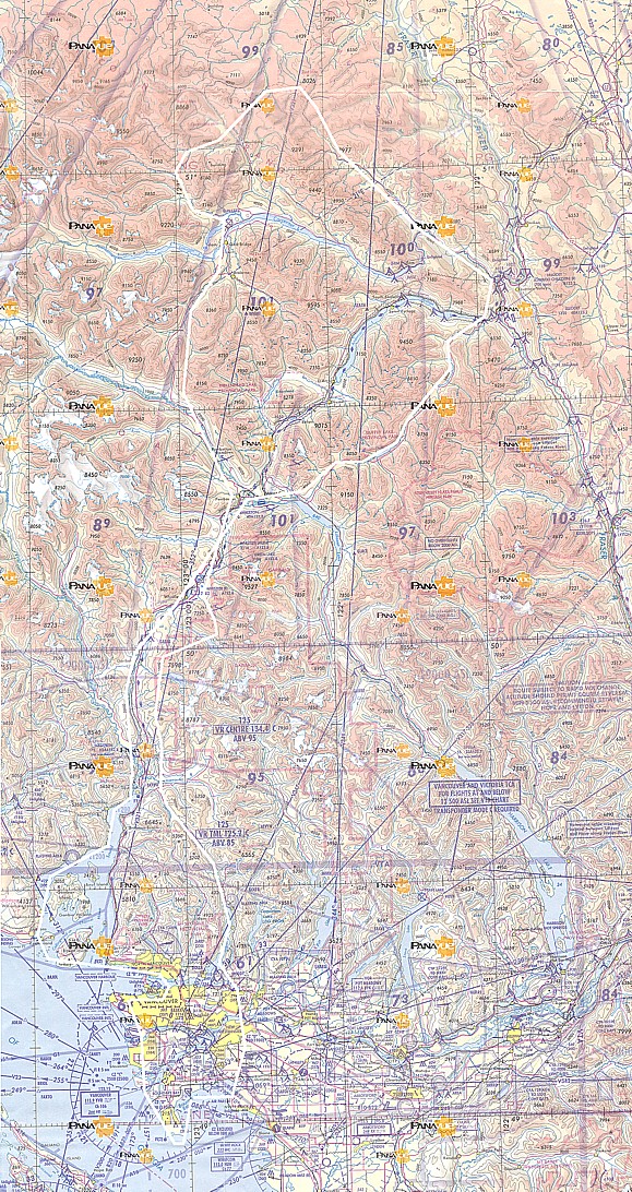
Here is a map of the route. Click here for a much larger detailed map.