Index of photo albums
-- randallg's homepage
-- Kat Kam
If you got here from a search engine and you do not see the photo index frame on the left,
click here
.
Comments and questions to randallg@telemark.net
From Boundary Bay to Revelstoke via Hope then direct Vernon. Then to Calgary via Rogers Pass, Golden, Yoho Park, Field, Kicking Horse Pass, Banff Park, Lake Louise, Banff. Then to Nelson via Banff, Vermilion Pass, Kootenay Park, Radium, Invermere, Cranbrook, Creston, Kootenay Lake. Then to Boundary Bay via Castlegar, Trail, Rossland, Grand Forks, Osoyoos, Keremeos, Cathedral Park, Manning Park, Hope. Featuring an overflight of Kokanee Glacier.
We left Vancouver on Thursday afternoon at 1700, leaving plenty of time to get to Revelstoke before the sun set sometime after 2000. Weather was mostly clear crossing the Coast Mountains on a beeline for the Enderby VOR. Crossing the plateau between Brookmere and the Okanagan Valley is relatively boring, at least for this part of the world.
- 001 - Cornfield maze in the Fraser Valley
- 002 - Hope - you can see the Hope Slide in the distance
- 003 - Hope Slide
We stayed overnight in Revelstoke at the Coast Hillcrest Hotel.
- 004 - 007 - View from the balcony
Taking off from Revelstoke Friday at 1430, we circled over the town and headed up the Illecillewaet River Valley towards Rogers Pass. We planned to follow the main highways to Calgary for this flight, which took about 2.5 hours. Passing through Rogers Pass at about 8000 on this beautiful, mostly cloudless day, was perhaps the most spectacular mountain flight we have ever made. Words fail me. Enjoy.
- 008 - 009 - Revelstoke in the Columbia River Valley
- 010 - Climbing up the Illecillewaet Valley over the Canadian Pacific Railway
- 011 - Looking north into Mt Revelstoke National Park, up Clachnacudainn Creek, to Mt Coursier in the centre and Inverness Peaks to the right
- 013 - Looking southeast up East Twin Creek
- 014 - Looking south up West Twin Creek
- 015 - 018 - Looking south up Siegfried Creek to Albert Peak - North Albert Peak is to the right
- 019 - Looking southeast up Albert Creek
- 020 - Looking south up Jumping Creek
- 021 - 027 - The ridge between Jumping Creek and Flat Creek - Fortitude Mt is to the right - in the distance is Mt McBean
- 028 - 030 - Looking south up an unnamed creek to Mt Smart
- 031 - 035 - Looking north at the Hermit Range just west of Rogers Pass
- 036 - 038 - Looking south up Loop Brook towards Mount Bonney
- 039 - Asulkan Ridge between Loop Brook and the Illecillewaet headwaters
- 040 - 042 - Illecillewaet headwaters featuring Mt Sir Donald
- 043 - 045 - Rogers Pass highway and old railway bed (it now goes through a tunnel)
- 046 - Mt Rogers is just north of Rogers Pass
- 047 - Mt Macdonald is just east of Rogers Pass
- 048 - Looking back at Rogers Pass while heading east
- 049 - 051 - Mt Macdonald which is just east of Rogers Pass
- 052 - On the way to Golden looking back at Rogers Pass
- 053 - Mt Sifton and Tupper Glacier in the background with Tupper Creek in the foreground
- 054 - The Beaver River just northeast of Rogers Pass
- 055 - Approaching the Columbia Valley looking north - this is Kinbasket Lake
- 056 - 057 - looking south down the Columbia Valley
- 058 - 059 - Rocky Mountains just north of Golden
After clearing Rogers Pass, we proceed over the town of Golden and follow the Trans Canada Highway to Calgary, through the Rocky Mountains. Our route follows the Kicking Horse River into Yoho National Park, through the Kicking Horse Pass into Alberta and Banff National Park, then follows the Bow River to Calgary.
- 060 - Town of Golden
- 062 - Proceeding eastwards along the Kicking Horse River
- 065 - 068 - This ridge north of the highway includes Mount Hunter and Porcupine Peak
- 069 - Looking south where the Kicking Horse River takes a corner
- 070 - 071 - Looking north up the Porcupine River
- 072 - Kicking Horse River looking south
- 073 - 075 - Ottertail Range east of the river, Mount Vaux in the centre, you can see the Hanbury Glacier at the top
- 075 - Mount Hurd in the foreground, in front of Mount Vaux
- 076 - 080 - Approaching the Kicking Horse Pass - the town of Field is below - to the right is Mount Stephen
- 081 - 084 - Looking north up the Yoho River Valley - you can see Takakkaw Falls to the right - in the distance is the Wapta Icefield with the Yoho Glacier in the centre
- 082 - Takakkaw Falls to the left and the Waputik Range and Waputik Icefield are in the centre
- 083 - Closeup of Yoho Valley, Takkakaw Falls and Yoho Glacier
- 085 - 087 - Cathedral Crags to the south of Kicking Horse Pass
- 088 - South of the pass looking up Cataract Brook, Narao Peak is in front and Mount Victoria is to the right
- 089 - Looking southeast along the Bow River, the town of Lake Louise in the centre and Lake Louise itself to the right
- 090 - Lake Louise ski area to the east of town
- 091 - 096 - Views of Lake Louise
- 097 - Moraine Lake and the Wenkchemna Peaks behind - this view was on the old Canadian $20 bill
- 099 - Mount Quandra
- 100 - Taylor Lake on the right, O'Brien Lake on the left, Mount Bell behind
- 101 - 104 - Castle Mountain
- 105 - 107 - Mount Assiniboine in the distance
- 108 - Sundance Range just southeast of Banff
- 109 - 116 - Town of Banff
- 114 - Banff Springs Hotel
- 117 - 118 - Town of Canmore
- 124 - 126 - Town of Canmore
- 127 - Spray Lakes Reservior
- 128 - Leaving the Rockies - this is the last range
- 129 - Town of Seebe
- 130 - Foothills to the east of the Rockies
- 132 - Ghost Lake
- 133 - The Bow River looking back at the Rockies
- 135 - Approaching Calgary
- 137 - Landing at Springbank Airport, which is the main GA airport, to the west of Calgary
We stayed two nights at the Sheraton Calgary West which is accross the road from Canada Olympic Park
- 139 - 145 - Natives
- 146 - 147 - Canada Olympic Park
- 149 - 155 - Our hotel had lots of memorabilia from the 1988 Winter Olympic Games in Calgary
We attempted to leave Calgary on Sunday for Nelson. The weather patterns these days were relatively clear mornings with thunderstorms developing along the mountains in the afternoon. 156 shows the view west from the airport, where a big thundercloud was perched right over the route to Banff. We took off to see if it was possible to circle around it to the north, but eventually had to turn back and return to Calgary. Some pilots may have made it through the mountains VFR but it was beyond my personal limits. On long final to the active runway 16, it became obvious there was a strong crosswind from due west, where the thundercloud was. The tower called and said that they could see the windsocks were showing a crosswind but it had sprung up so fast that their measuring equipment hadn't indicated it yet. They offered to send me to runway 25 instead, but my approach was going well and I said I would give it a try. There was some shear on short final but not bad, and I made (if I may say so myself) a nice landing in the 15 knot direct crosswind. On rollout the tower called and congratulated me on a fine landing! Woo Hoo! We stayed downtown this time and wandered around the Eau Claire market area, and had dinner at the excellent River Cafe in Princess Island Park.
- 157 - Princess Island Park
- 159 - 165 - River Cafe with views out the window
- 170 - Abdul the friendly cab driver, a recent immigrant from (IIRC) Lebanon.
We left a little earlier on Monday and managed to beat the afternoon thunderstorms. We wanted to go to Nelson and FSS did not know if the Rockies were passable for VFR. I am a little disappointed about that - I think it would be appropriate to have a couple of automatic weather stations through there. So once again we set out but this time it was passable - there were lots of little clouds around some of the mountains but the valley centres were clear. We followed the main route past Banff to the intersection of Highway 93 and followed that road into the Columbia Valley. The Vermilion Pass was plenty clear and we had no trouble overflying the length of Kootenay National Park on the way to Radium Hot Springs. Then we took the Columbia Valley south to Cranbrook, Highway 3 to Creston, then Kootenay Lake all the way to Nelson. The worst conditions were between Cranbrook and Creston where the ceiling dropped to as low as 6000 ft in one spot.
- 171 - 186 - The first range of the Rockies on the way to Banff
- 187 - 189 - Lake Minnewanka northeast of Banff
- 190 - Mount Norquay
- 191 - 194 - Sawback range north of the highway, west of Banff
- 195 - 196 - Castle Mountain
- 197 - Highway 93 intersection
- 199 - 200 - From Vermilion Pass looking at Boom Lake, with Chimney Peak and Mount Quadra behind
- 201 - Mount Whymper on the left, my map does not name the creek
- 202 - 205 - Stanley Peak south of Vermilion Pass
- 206 - Mount Whymper
- 207 - Tokum Creek
- 208 - This unnamed (on my map) 9100 ft peak is above Marble Canyon
- 209 - In the distance is the Rockwall and Wolverine Pass - the unnamed 8600 ft peak is south of Tumbling Creek
- 210 - Numa Creek with the Rockwall behind
- 211 - 212 - This steep 8600 ft peak is just west of the highway, south of Numa Creek
- 213 - Mount Numa to the left, the Rockwall is behind
- 214 - Floe Creek with the Rockwall behind - unfortunately we can't quite see Floe Lake
- 215 - Closeup of the Rockwall above Floe Lake
- 216 - 217 - Mount Verendrye
- 218 - 219 - Kootenay River Valley
- 220 - 221 - The clouds parted enough to see Mount Assiniboine from the west -
- 222 - Looking back up the Kootenay River Valley
- 224 - 226 - Approaching Radium Hot Springs
- 228 - 230 - Town of Invermere in the Columbia Valley
- 231 - 233 - Looking at Kimberley in the distance
- 234 - Cranbrook Airport
- 235 - 237 - Cranbrook
- 238 - This was our heaviest weather near Moyie Lake
- 239 - 240 - Passing north of Creston
- 241 - 242 - Flying north up Kootenay Lake
- 243 - This is Balfour, where an arm of Kootenay Lake extends west to Nelson
- 244 - 245 - Higways ferry
- 246 - Looking back at Balfour
- 247 - A glimpse north of Kokanee Mountain
- 248 - West arm of Kootenay Lake
- 249 - Kokanee Creek Provincial Park
Nelson was clear with some cumulus around. It's an interesting place to land a plane - the airport is right downtown on the banks of the Kootenay River, in a relatively narrow valley. No circuits here! We flew over downtown at 1500 agl to figure out the wind, and then circled back east along Kootenay Lake a few miles, then turned around for a five mile final to runway 22. It was about 1530 and we had to decide whether to return to Vancouver that day. The cumulus was growing and the weather west sounded a bit iffy. We decided to stay the night and it was a good decision as a thunderstorm went through a little later, soaking the town.
- 252 - Over Nelson's bridge accross the Kootenay River/Lake
- 253 - Nelson's north shore from directly above the airport
- 254 - Looking west from Nelson down the Kootenay River
- 255 - 259 - Circling over the city
- 260 - 267 - Five mile final into Nelson airport
- 268 - 269 - Nelson Airport
Nelson is a wonderful town and we highly recommend it as a place to visit. We stayed at the Baker Street Inn downtown and had a view of the airport from our room. Downtown Nelson has plenty of heritage buildings and the town has done a great job of maintaining and improving it. There are lots of funky restaurants and we had dinner at one of the best - All Seasons Cafe. It reminded us of Vancouver. We trundled around town the next day in the sun and got tons of photos.
- 270 - 272 - View from the hotel
- 273 - All Seasons Cafe
- 275 - They roll their own in Nelson
- 277 - 281 - More views from the hotel
- 282 - 363 - Nelson walkabout
The next day it was back home to Vancouver. The weather was excellent and after fueling up we left at about 1530. Taking off from runway 04 we headed east along Kootenay Lake while climbing to about 9000 feet. Then we turned north for an overflight of Kokanee Glacier Park and the famous glacier (you know, the one on the Kokanee beer bottles). After that we followed the Kootenay River past Nelson, Castlegar and Trail. Turning west we passed Rossland, Christina Lake, Grand Forks, Midway, Rock Creek, Osoyoos, Keremeos, Ashnola River, Placer Mountain, Manning Park, Hope, then to Boundary Bay.
- 364 - 367 - Fueling up at Nelson airport
- 368 - Just after takeoff
- 369 - Circling over Kootenay Lake
- 370 - 371 - Mount Drewry just south of the Kootenay River and west of the lake
- 373 - Gibson Lake - this is where the road ends and the trail begins into Kokanee Glacier Park - you can see the trail switchbacking up the steep eastern shore
- 374 - 375 - Kokanee Lake with Kokanee Mountain above
- 375 - This is where Michel Trudeau, son of the late Canadian Prime Minister, was killed when an avalanche swept him into the lake while on a backcountry ski trip - he was traversing that steep slope on the east side - his body has not been recovered
- 376 - 384 - We pass west and north of Kokanee Glacier, then turn around and head south back to Nelson
- 377 - The Joker Lakes are vastly different colours - behind is the Sawtooth Ridge
- 379 - Kokanee Glacier is smaller than I expected, at least from this angle
- 381 - Joker Lakes
- 388 - 395 - Overflying Nelson at 10000 feet
- 396 - 400 - Kootenay River between Nelson and Castlegar
- 399 - Looking north up the Slocan Valley
- 401 - 403 - Castlegar - here the Kootenay River runs into the Columbia River
- 405 - 408 - along the Columbia River south of Castlegar on the way to Trail
- 409 - Trail airport
- 410 - 412 - Passing over Trail
- 411 - Cominco's lead/zinc smelter - the largest in the world
- 413 - 414 - Just west and up the hill is the town of Rossland
- 414 - Next to town is the Red Mountain ski area
- 415 - 417 - Christina Lake from the south
- 418 - 420 - City of Grand Forks
- 422 - 423 - Town of Greenwood
- 425 - Vicinity of the town of Midway
- 427 - 428 - Rock Creek on the Kettle River
- 429 - 434 - Town of Osoyoos and Osoyoos Lake from the south
- 436 - Mount Kobau
- 437 - 439 - Okanagan Valley and the town of Oliver
- 440 - Cawston in the Similkameen Valley
- 441 - Keremeos
- 442 - Looking up the Similkameen Valley towards Princeton - we branched off here and followed the Ashnola Valley for a more direct route
- 443 - Looking southeast over the Okanagan Range of the Cascade Mountains
- 444 - Crater Mountain - there is a 4x4 road to the top of it
- 445 - 446 - Ashnola River
- 448 - Cathedral Mountains
- 451 - Entering Manning Park, this is Blackwall Peak - in the distance are the Three Brothers and the meadows
- 453 - Three Brothers alpine meadows
- 454 - Three Brothers
- 457 - 458 - Three Brothers from the west with Nicomen Lake in the foreground
- 459 - Heading for Hope
- 462 - 463 - Mount Dewdney
- 465 - Hope Slide - Macleod Peak is behind
- 466 - 469 - Mount Baker in the distance
- 470 - Cheam Peak
- 472 - Harrison Lake in the haze
- 473 - 477 - A bunch of mountains in the haze
- 478 - Some heritage park east of Mission
- 479 - 480 - Landing on 25 at Boundary Bay
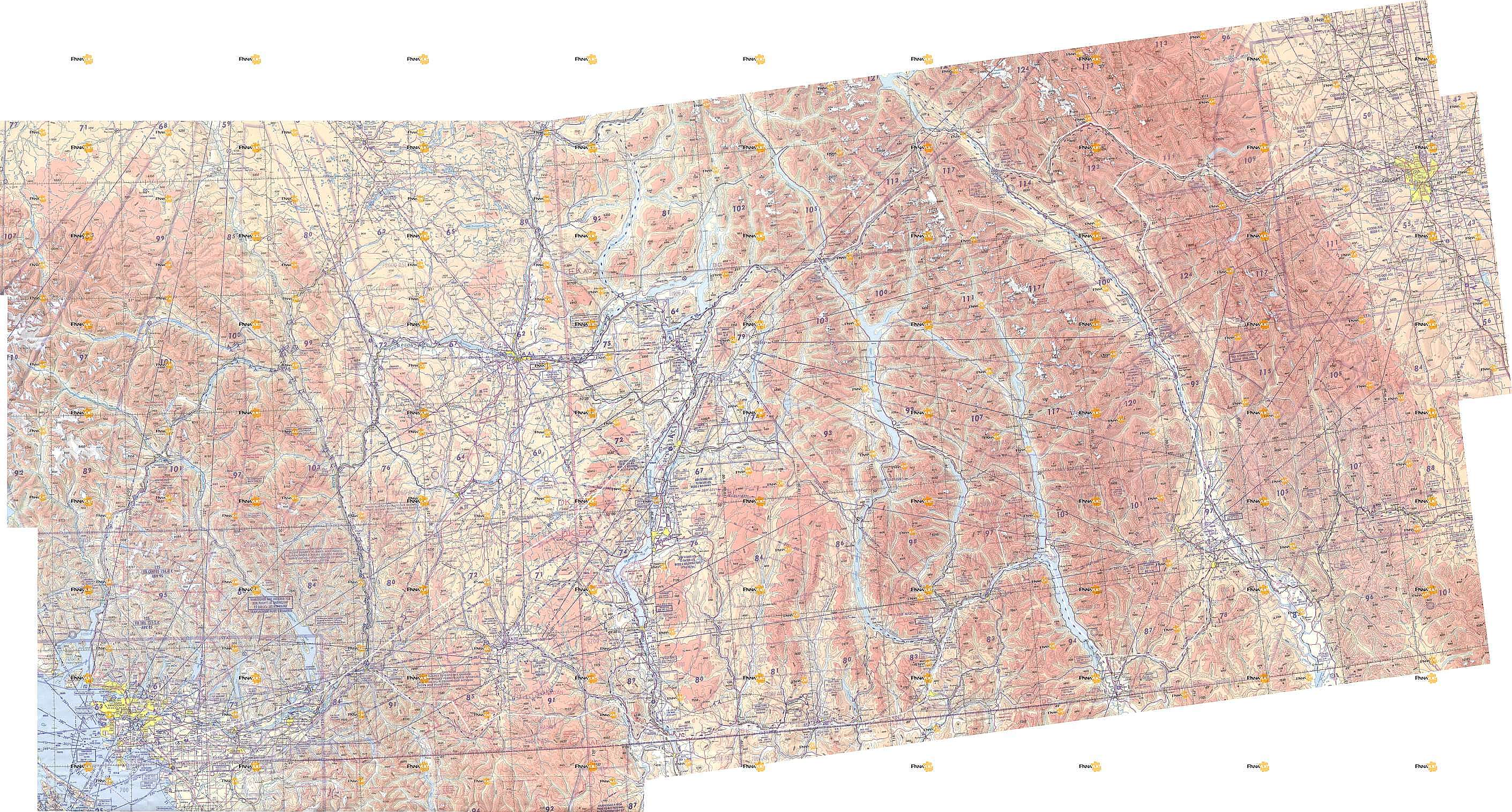
Here is a map of the route. Click here for a much larger detailed map.