Index of photo albums
-- randallg's homepage
-- Kat Kam
If you got here from a search engine and you do not see the photo index frame on the left,
click here
.
Comments and questions to randallg@telemark.net
This is a log of a trip we made from Vancouver to Tumbler Ridge and back, August 3-8 2002. My brother lives there and works as a surveyor in the gas fields, and as a part-time candidate for the provincial Unity Party. My intention was to visit Tumbler Ridge for a couple of days, and then fly to Calgary via Jasper and Banff to visit friends there. Unfortunately the weather made this impossible so we returned to Vancouver and visited Calgary later on another trip (check the index). We chose this time to fly into Tumbler Ridge because they were having their annual Grizfest over the August long weekend. This is an almost unique music festival that brings in some very eclectic artists from British Columbia and elsewhere to this obscure little town.
We had intended to leave on Friday to catch both nights of the festival but the Coast Mountains were closed that day due to weather. We went down to the airport, but after a last-minute weather briefing I had to call off the flight. Saturday was marginal, but we took off at 1100 to check out the Fraser Canyon route and it turned out to be passable. The canyon from Hope to Cache Creek was scattered 7500' over the ridges, with the centre of the valley clear. I called Kamloops FSS and gave them a PIREP. From Cache Creek to Prince George it was pretty consistent broken cumulus at about 8000' and it was fun navigating around the bases at 8000'. We landed and refueled in Prince George, then took off at about 1530 with broken cumulus at 7500'. FSS couldn't tell me whether I could make it across the northern Rockies or not, as there is no weather station between there and Dawson Creek. An earlier PIREP said Pine Pass was passable with moderate turbulence. I called my brother in Tumbler Ridge and he said it was overcast with a bit of blue shining through, but he couldn't give me an accurate ceiling height. So anyway, we took off to try to follow the BC Rail route to Tumbler Ridge, knowing that if it was impassable we may need to head north and try the much lower Pine Pass, or even abort and return to Prince George. Everything looked good until we got right to the divide, and then the ceiling dropped precipitously with rain immediately to the east. You can see in one of the photos what the route to Tumbler Ridge looked like at that point. There was no choice in my opinion but to turn around and try the Pine Pass far to the north, costing us about 1.5 hours. You can see on the map how close we were to Tumbler Ridge - about 20 minutes. Oh well.
Pine Pass was just fine for VFR. There were scattered cumulus over the ridges at about 7500', and a higher ceiling, so I kept to the centre of the valley and avoided them handily. There was no turbulence, and I had to wonder what the PIREP pilot was flying and how high. Approaching Chetwynd, I called Fort St John FSS and gave them a PIREP of the Pine Pass route. Then we turned southeast to follow the secondary highway to Tumbler Ridge. We were well east of the higher mountains and the ceiling kept us down to about 6000', which was fine for the area. Visibility was good and there were scattered showers which we had no problem navigating around. Approaching the town of Tumbler Ridge, we did a 360 around it for some photos, not knowing that my brother, expecting a small airplane with us in it, had run out into the street in front of his house and was waving like mad. Having never been there, we didn't see him or even know where his house was.
After circling the town we headed south for 7 nm to find the airport. The CFS has an interesting warning about this: "moderate to severe turbulence & wind shear may be encountered on appch." That seems kind of weird given that the airfield is on a pretty flat plain and there are no sizeable hills nearby, but it turned out to be true. I had to fight changing winds on short final and decided to land a bit long, which was no problem on the 4000' runway. I tied down on the small apron and there was the Pathfinder my brother had left for me, to drive into town and check into the only hotel.
We found the hotel and checked in at about 1830. Then we headed down to the community centre and paid our $10 to watch the Grizfest music show. I was pleased that we were able to catch most of the Uzume Taiko performance. I have seen them in Vancouver and they are very entertaining. They did a great interactive show for a bunch of the local children, and even though I normally can't stand children, I thought it was cute as hell. About this time my brother showed up so we went to have a couple of beers at the beer tent to catch up. After that we caught Ivonne Hernandez, an incredible Celtic-style fiddler from Victoria BC. My goodness I love good Celtic music. We had to leave for supper after for that because the only open cafe in town was going to close (at the hotel) and we had to miss Luther Wright and the Wrongs who have recorded an interesting bluegrass version of Pink Floyd's "The Wall."
The next day we drove the Pathfinder to Kinuseo Falls in Monkman Provincial Park, about 50km to the south along a gravel road. We passed some of the immense coal conveyors that bring the coal down from the mountaintops where it is mined, or used to be mined anyway. We had planned to leave the day after that, but the weather was still socked in and there was no way I was going to fly. The intention was to fly to Calgary for two nights, but this blew our reserve weather days out of the water. So I booked the hotel for another night and hoped we could get out the next day. We hung around and took pictures of soggy fauna around town.
The third day there was mostly clear, but we had to head back to Vancouver. We headed out to the airport about noon, and for fun stopped at a local shooting range and fired my brother's rifle at a target. We hadn't handled a gun before and it was quite interesting. I filed a flight plan for Prince George via Monkman Lake and the McGregor River. After taking off, we circled the town once more and then headed south. We passed over the airport again, and then over Kinuseo Falls. Then we had a most spectacular flight through the Rockies at about 7500', surrounded by scattered cumulus but with no ceiling this time. Arriving in Prince George was uneventful and we parked at the Shell FBO. As it was getting a bit late for the 3.5 hour flight to Vancouver, we decided to stay for the night at a hotel downtown. The airport is sufficiently far from downtown that it costs about the same to rent a car as to take a taxi both ways. Ric's Grill provided us with a Vancouver-quality dining experience.
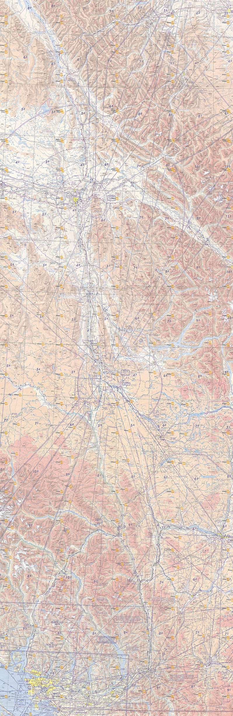
Here is a map of the route. Click here for a much larger detailed map.