Index of photo albums
-- randallg's homepage
-- Kat Kam
If you got here from a search engine and you do not see the photo index frame on the left,
click here
.
Comments and questions to randallg@telemark.net
The first flight is from Boundary Bay to Williams Lake. My planned route is Hope, Kamloops, Clearwater, Helmcken Falls, 108 Mile House and Williams Lake.
The second flight is from Williams Lake to Barkerville, routing via Quesnel. The third flight is from Barkerville to 108 Mile House. I had planned to fly to Bowron Lakes, south along the Cariboo River to Likely, south to Horsefly, southeast to Hendrix Lake, Canim Lake, then east to 108 Mile. However the weather was not cooperating. Leaving Barkerville there was some serious rain to the east, so I just flew back to Quesnel and followed the highway south to 108 Mile.
The final flight is from 108 Mile back home to Boundary Bay. I wanted to go via Lillooet and Whistler because the scenery is better, but there was a major forest fire just west of Lillooet and the current NOTAM prohibited entry into the area because of water bomber activity. So instead we flew east over the Cariboo plateau to get some pictures of the resort lakes area, then south along the Thompson and Fraser rivers to Hope.
Piloting by Randall. Photography by Kat.
After takeoff from Boundary Bay, we are cleared by Vancouver Terminal to 7500 feet eastwards to Hope.
- 001 - Mount Baker
- 002 - Mount Baker, with Fraser Valley farmland in the foreground
- 003 - Mt Cheam
- 004 - Fraser Valley just east of Agassiz
Hope is a good soaring area. We had to dodge some gliders. We turn northeast to follow the Coquihalla Highway to Kamloops.
- 005 - Glider in flight near Hope
- 006 - Hope Mountain, just north of the intersection of the Hope-Princeton and Coquihalla highways
- 007 - Nice view northeast of the Coquihalla Highway
- 008 - More Coquihalla Highway
- 010 - Tulameen Mountain
- 011 - Yak Mountain just west of the highway
- 012 - Upper Coquihalla River. You can see the highway high on the left. The Kettle Valley Railroad used to run up the canyon
- 013 - Closeup of the canyon
- 014 - Dry Gulch. The highway crosses it lower down. You can see the pipeline road going over the ridge and down back to the highway on the upper left. If you have 4wd you can drive this road and avoid the tollbooths, which you can see on the highway. I got stuck in the snow there once
- 015 - Another view of the tollbooth-avoiding-road
- 018 - Upper Coldwater Valley with Merritt in the distance. You can see the highway and the railroad bed
- 019 - Merritt
- 022 - Merritt Airport
- 023 - Looking east to Nicola Lake
- 026 - Between Merritt and Lac Le Jeune
- 027 - Lac Le Jeune area
- 030 - Lac Le Jeune ski hill, now closed
- 032 - Stake Lake. There is good cross country skiing around here
- 033 - Kamloops subdivision
We proceed past Kamloops northeast to Mt Tod to have a look at the Sun Peaks ski resort. Then north along Louis Creek and the North Thompson River to Clearwater.
- 034 - Kamloops Airport
- 035 - Looking east along the South Thompson River
- 037 - I didn't know about this ski hill just northeast of Kamloops
- 038 - Sun Peaks ski resort
- 040 - Tod Mountain
- 041 - Just north of Clearwater looking southeast
- 042 - Raft Mountain
- 044 - Trophy Mountain. You can do some great hiking in the meadows here - they are full of spectacular flowers in late July and early August. Unfortunately they are not in bloom at this time
We are now at the southern edge of Wells Gray Park. The plan is to find Helmcken Falls and circle it. The falls are about 400 feet high and very spectacular.
- 049 - Green Mountain with viewing platform to the right
- 050 - 050-062 Circling Helmcken Falls. What a rush
On to Williams Lake. Rather than fly to 108 Mile first, I decide to save some time and go direct. Advising Williams Lake Radio of my intentions, I follow the 060 radial from Canim Lake to the Williams Lake VOR.
- 064 - Bills Pond is in view
- 065 - Landing at Williams Lake airport
- 070 - Doh! Missed by 8 feet!
Leaving Williams Lake we head north to Quesnel and then Barkerville. We plan to spend a couple of hours checking out the Barkerville Historic Site.
- 071 - Williams Lake
- 077 - Looking north up the Fraser River
- 078 - Quesnel
- 081 - Quesnel Airport
- 082 - Heading east to Barkerville
Landing in Barkerville is interesting. It is probably the trickiest airport in BC if not the country. The altitude is 4060 feet and the runway is 2700x40, making performance an issue. This is the second highest paved airstrip in Canada. I checked it out thoroughly ahead of time and my Cardinal, being 300 pounds under gross, should have no problem with that. The aerodrome is in a narrow valley, making a normal circuit impossible. I had a chat with a local pilot at the Williams Lake Flight Service station about Barkerville and he gave me some good advice. The runways are 11 and 29. There is high terrain to the south and runway 11 has a 2% upslope, so basically it is one way. You really want to land southwards on 11, and takeoff northwards on 29, even if you have to accept a tailwind. Looking at the terrain, it may be possible to takeoff from 11, if you make an immediate left turn, but I sure wouldn't want to try it. The pilot I spoke with told me there were several airplanes stuck on the hillside to the south, and I can believe it. So anyway, I flew over Wells and made the right turn to overfly Barkerville airstrip at about 1500 feet above aerodrome elevation. I would not want to go much lower in that narrow valley, it would be more difficult to turn around. I noted there was about a 10 knot wind from the south which will make the landing easier but may cause problems when leaving. So after turning around, it's back to Wells to begin the descent where there is more room to manoeuver. What you do is start a right base over Wells before you can even see the airstrip. Then it's a right turn to final and the airstrip comes into view, right where it's supposed to be.
- 084 - Wells
- 088 - Turning right towards Barkerville, you can see the airstrip. I am 1500 feet higher to inspect the conditions
- 089 - Looking back towards Wells. You cannot see Barkerville from Wells
- 090 - Barkerville townsite
- 092 - We turn around and head north towards Wells
- 094 - On final for runway 11. Look at the terrain you have to deal with if you try to take off from runway 11. Yikes!
- 097 - I manage to land in the centre, which is a good plan for this narrow runway
After landing it's a 22 minute walk to the townsite. The following pictures 098-215 are taken in Barkerville. I am not going to try to describe them all!
- 098 - 098-215 Various images of Barkerville
We trudge back from Barkerville to the airport. The fairly stiff south wind was causing me some worry, but by now it has died down and is gusting to no more than 5 knots. Phew! I would not try to take off with a tailwind much stronger than that. After the usual runup checks, I perch at the end of runway 29 and, holding the brakes, apply full power. I have never had to lean the mixture on the ground before, but it's not hard. It is pretty obvious where the maximum power position is - MP doesn't change much but the prop RPM does and I maximize that. Then, releasing the brakes, we barrel down the runway. I can feel the small tailwind but it is not a problem, and we are off with plenty of runway to spare. Good thing it's a 2% downgrade! We climb at 77mph with 15° flaps for best performance. I was a little worried about terrain clearance too, but it is not a problem. You can turn slightly left to avoid the trees, and stay over the road, and a little later turn left to overfly Wells. The terrain does not rise so if you have any climb performance at all you will be OK.
- 216 - The Barkerville airport is at the junction of the road to Bowron Lakes. I was the only plane there that afternoon
- 218 - Budweiser is the stupid man's beer
- 220 - Note the trees beyond the runway. While clearing them is probably not a problem, if you angle a bit to the left you can avoid them completely
The plan, as described above, was to head northeast and fly through the mountains. It looked like steady rain in that direction so I decided to head west to Quesnel and then south to 108 Mile House.
- 221 - Westbound for Quesnel
- 223 - Quesnel's local ski hill
- 224 - Quesnel River
- 227 - Huge open pit mine 20 miles north of Williams Lake
- 231 - Fraser River at Soda Creek
Approaching 108 Mile House airport from the northeast.
108 Lake, 108 Resort and the golf course, after passing over midfield
- 238 - Crossing midfield again to join right downwind for 32
- 239 - - 240 The Hills Guest Ranch one of the premier spa and wellness resorts in the province
- 240 - Note how close it is to the runway at 108 Mile House airport
- 241 - I know it looks like a left base but I got blown a bit by the wind
- 244 - - 249 pictures from The Hills
- 250 - a Lake amphibian at the 108 Mile airport
The next photos are of the unfortunate Cessna 172 C-GWAC. We looked it up later and it was involved in an accident in 1999. It was on a straight in approach to runway 32 when it collided with another C172 that was doing circuits and turning final. The other airplane was doing left circuits although it is supposed to be right circuits for 32. GWAC was broadasting on the wrong radio frequency and looking for right traffic, so the two aircraft were unaware of each other. Amazingly the three persons involved were not killed. Click here for the TSB report of this accident.
- 251 - Poor C-GWAC
Leaving 108 Mile House we depart for Boundary Bay. I wanted to go via Lillooet and Whistler, but there were some forest fires near Lillooet and a NOTAM advised not to enter the area just west of Lillooet where the VFR route goes over Seton Lake. So instead we followed the Fraser Canyon south to Hope which turned out to be not as boring as I thought. The view is so much better from the air than it is from the road! On the way, we flew eastwards to get some views of the Cariboo resort lakes area past Sheridan Lake, circled Bridge Lake, passed Green Lake and then south past Chasm, Clinton, Cache Creek, and Lytton to Hope.
- 253 - 100 Mile House just south of the airport
- 257 - That is Green Lake well to the south - we eventually pass south of it
- 259 - - 264 Passing north of Sheridan Lake
- 266 - - 281 circling clockwise around Bridge Lake. 275 shows the provincial campground on a peninsula on the south side of the lake. It is a great spot to camp
- 274 - Complete view of Bridge Lake to the west, with Sheridan Lake in the upper left
- 282 - - 288 Passing south of Green Lake
- 289 - 70 Mile House
- 290 - - 292 Some views of Chasm
- 295 - Clinton
- 297 - Bonaparte River
- 298 - Cache Creek - check out the golf course in the desert
- 302 - Cache Creek Airport
- 303 - Ashcroft
- 305 - Highland Valley Copper Mine
- 306 - Spences Bridge
- 308 - Thomson River
- 315 - Lytton - you can see the defunct airfield to the right. The clear Thomson River meets the muddy Fraser River here
- 319 - Heading south down the Fraser Canyon to Hope
- 325 - Approaching Hope where the Fraser River turns west to flow to Vancouver. The Fraser Valley often gets filled with low marine cloud (and sometimes some smog) which the prevailing westerly winds push up the valley towards Hope. The valley narrows there and you can see the cloud spilling over the ridges around Hope
- 330 - I had to descend to below 2000 feet to get under the cloud
- 331 - Harrison Mills
- 334 - Mission
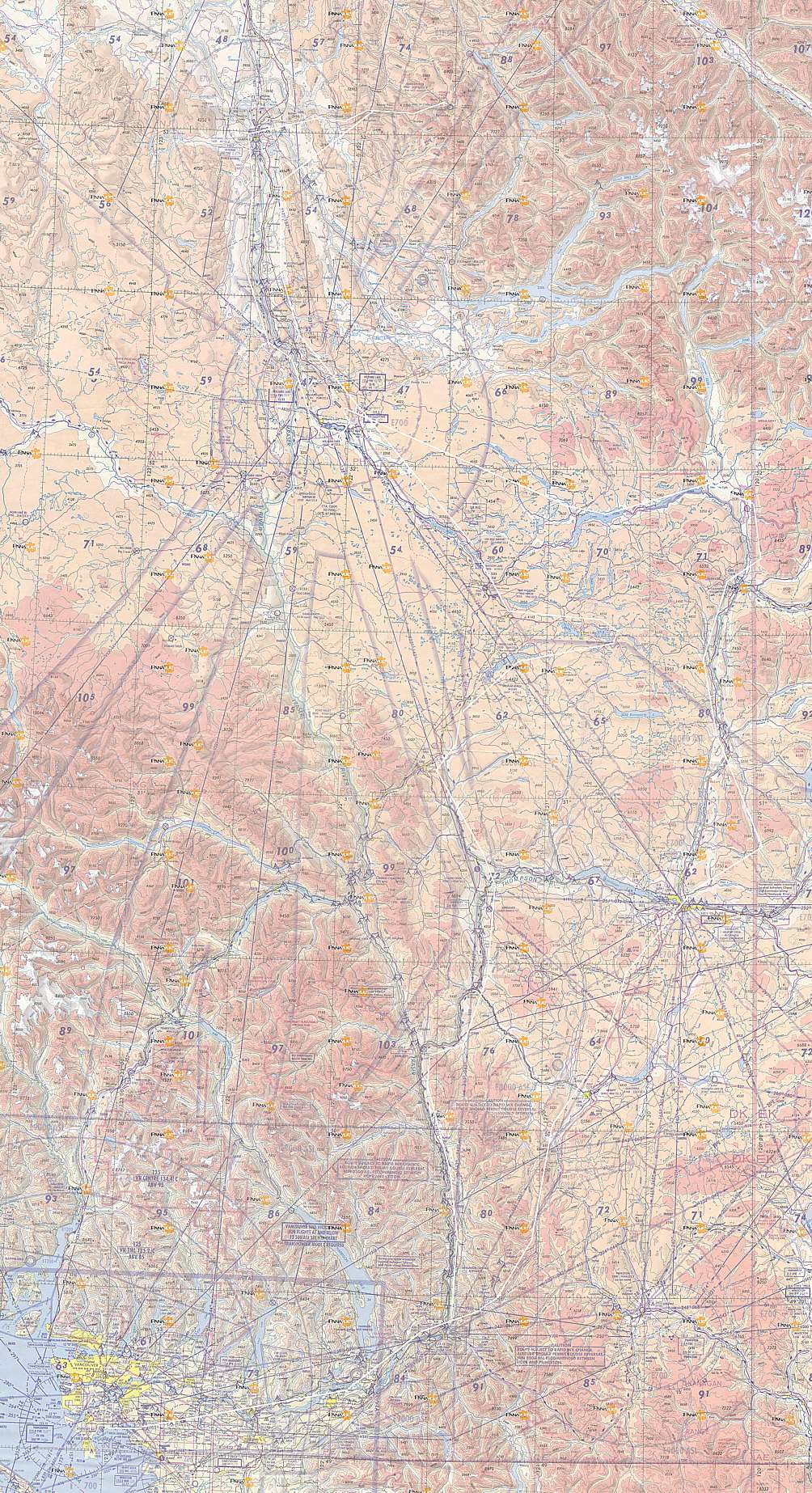
Here is a map of the route. Click here for a much larger detailed map.