Index of photo albums
-- randallg's homepage
-- Kat Kam
If you got here from a search engine and you do not see the photo index frame on the left,
click here
.
Comments and questions to randallg@telemark.net
Here is a flight from Boundary Bay to Lillooet and back. It was a beautiful day in June.
This page is best viewed at a resolution of at least 1600x1200 and with a fast Internet connection. The photos are at a native resolution of 1280x960, but they will resize to the size of your browser window. You may find it convenient to open the photos in a separate browser window - click your right mouse button and select "Open Link in New Window."
Piloting by Randall. Photography by Kat.
- 001 - Port Moody
- 002 - Sasamat Lake
- 003 - Indian Arm
- 004 - Belcarra
- 005 - 006 - Mt Seymour
- 007 - 010 - Lynn Valley
- 011 - 013 - Grouse Mt in front, Mt Seymour behind
- 014 - 016 - Capilano reservoir
- 017 - In the centre are the Lions - a bit hard to see
- 018 - Black Mt and Howe Sound
- 019 - The Lions
- 020 - The whole North Shore and Burrard Inlet
- 022 - 024 - The Lions and Lions Bay
- 024 - 025 - Deeks Lake
- 027 - 026 - Tantalus Range
- 029 - Phyllis Creek and the Capilano River valley
- 030 - Brittania Creek
- 031 - 032 - Sky Pilot Mt
- 033 - Tantalus Range
- 034 - 037 - Squamish and Brackendale
- 038 - Mt Garibaldi on the left, Paul Ridge to the right
- 039 - 043 - Tantalus Ridge
- 044 - 047 - Mt Garibaldi
- 048 - Table Mt
- 049 - 051 - Garibaldi Lake
- 052 - 057 - Black Tusk
- 058 - Cheakamus Lake
- 060 - 062 - Whistler Mountain
- 063 - 064 - Blackcomb Mountain
- 065 - 068 - Mt Weart on the left, Wedge Mt on the right
- 069 - Mt Currie, Lillooet River valley is behind
- 070 - 072 - Lillooet River valley, the Pemberton airport is visible - the valley to the upper left is the Duffey Lake road
- 074 - 077 - looking south at Mt Currie
- 078 - 080 - Lillooet Lake
- 080 - Turning northeast up Joffre Creek along the Duffey Lake Road
- 081 - 087 - Mt Matier, Joffre Peak, Matier Glacier, and Upper Joffre Lake
- 085 - Joffre Peak is on the right and Mt Matier is on the left
- 088 - Looking south down Caspar Creek, Mt Matier is to the right
- 089 - Joffre Peak on the right, Mt Matier on the left
- 090 - Looking south down Van Horlick Creek - in the distance is the headwaters of the Stein River
- 091 - That's the Cayoosh Canyon up ahead
- 092 - Behind the nearby unnamed ridge is the Blowdown Creek valley - the valley in the distance is the Fraser River
- 093 - Looking south along Van Horlick Creek
- 095 - 096 - Looking southeast that is the Blowdown Creek valley
- 097 - 100 - Looking east in the general direction of Mt Brew - the valley behind is the Fraser River
- 101 - Looking south along Gott Creek
- 102 - Looking south at the unnamed 9000' peak to the east of Gott Creek
- 103 - Looking west up the Downton Creek valley - we are beginning the descent to Lillooet which we cannot see yet
- 104 - Looking east to Mt Brew
- 105 - Downton Creek again
- 107 - We cross over the ridge to Seton Lake to continue the descent to Lillooet - just beyond that pass past the lake
- 111 - Looking up Cayoosh Canyon where the road goes - I didn't want to descend through there
- 112 - 115 - Approaching Lillooet airport and doing a left circuit for 32
- 116 - As you can see there is a cliff just in front of the runway. It was quite turbulent so I made a high approach and landed long
Taking off from Lillooet, we head northwest up the Bridge River, and follow Carpenter Lake west to Gold Bridge
- 129 - Slopes of Fountain Peak east of Lillooet
- 130 - Ginseng farm
- 131 - The old highway bridge at Lillooet over the Fraser River
- 132 - And the railway bridge just north of town
- 133 - Proceeding northwest up the Bridge River, this is the Camelsfoot Range between the Bridge and Fraser Rivers
- 134 - 137 - settlement in the lower Bridge River Valley
- 138 - This logging road crosses the Bridge River about 6km southeast of Moha, just west of Camoo Creek
- 139 - Looking back to where the Applesprint Creek meets the Bridge River
- 140 - 141 - Some of the lush slopes on the north side of Mission Ridge
- 142 - 143 - Just about above Moha, looking back down the Bridge River
- 144 - Looking northwest up the Yalakom River, we continued a little farther in order to gain enough altitude to fly over the Bridge River canyon
- 146 - We have now turned around and are heading south over the Bridge River Canyon - this is the Shulaps Range
- 147 - 150 - Bridge River Canyon, between Moha and Carpenter lake
- 151 - The Terzaghi Dam which holds in Carpenter Lake
- 152 - 160 - The Bendor Range south of Carpenter Lake - the valley beyond it contains Anderson and Seton Lakes
- 161 - Looking north from Carpenter Lake, the junction of the Marshall Creek Road, behind is Rex Mountain and the Camelsfoot Range
- 162 - Mt Bobb in the Bendor Range
- 164 - Mt Bobb
- 165 - 166 - Bobb Creek and Bobb Lake are between Mt Bobb on the left, and Mt Williams on the right
- 167 - Mt Williams on the left, with Truax Creek and Mt Truax on the right
- 168 - Looking back down Carpenter Lake with the Camelsfoot Range in the background
- 170 - Gun Lake and Dickson Range behind featuring Dickson Peak, with Gun Creek valley to the right. The Gun Lake airstrip is a comfort even though it is closed.
- 172 - 172 - Bendor Range from Gold Bridge
- 173 - 176 - Downton Lake - behind is the Dickson Range
- 177 - 178 - West up the Bridge River Valley - there is a forest fire up there - in the distance is the huge icefield around Bridge Peak and Stanley Peak
- 179 - 181 - The range south of Downton Lake featuring Mt Sloan
- 182 - Following the Hurley River south, looking west, Lone Goat Creek is on the left and the Downton Lake valley is behind this range
- 183 - 185 - Looking west, Lone Goat Creek is on the right, and on the left, the Hurley River Valley starts to curve west.
- 186 - Looking west up the Hurley River Valley to the right, the tributary that runs down from Mt Samson is in the left and centre. Mt Samson is just out of view to the left
- 187 - 188 - We are passing over Railroad Pass, looking west to Mt Samson in the upper right
- 189 - 191 - Ridge immediately west of Railroad Pass
- 192 - From railroad pass we reach the Lillooet River and turn to Pemberton. This is facing west up the Lillooet River Valley. The deep valley that turns left from the Lillooet in the upper right is Meager Creek, where the famous hotsprings are. The two nearby high points of the ridge in front of Meager Creek are Overseer Mountain and Spidery Peak
- 194 - 195 - The ridge just southwest of Lillooet River. In the distance on the left is Blackcomb, Whistler, and the Black Tusk
- 196 - Lillooet River
- 197 - 200 - we take the corner at Pemberton and head south for Squamish. These are looking west at Ipsoot Mountain
- 201 - Looking west up Rutherford Creek
- 202 - In the centre is Mt Weart, and to its right is Wedge Mountain. Far behind the Lillooet River continues south to Harrison Lake
- 203 - Looking west up Soo River
- 204 - Phalanx Mtn in the near centre, Blackcomb Peak to its right
- 205 - Wedge Mt on the left, Blackcomb on the right, Wedge Creek in the middle
- 206 - 208 - Looking west at Rainbow Mt
- 209 - Black Tusk
- 210 - Mt Garibaldi is to the left of the Tusk
- 212 - Looking east at Cheakamus Lake, the lower left ridge is the Musical Bumps - Whistler, Piccolo, Flute and Oboe summits
- 213 - The spiky Mt Fee, with the Squamish River behind
- 214 - Looking northwest at Mt Fee, the lower summit in front is Mt Brew
- 215 - Mt Fee
- 216 - 217 - Cutting between Cloudburst Mt and Tricouni Peak to the Squamish River, looking northwest up the Squamish River Valley
- 218 - 231 - We reach the Tantalus Range and skim the east side of it, descending towards the town of Squamish
- 221 - Zenith Lake
- 227 - And Lake Lovely Water
- 232 - 238 - Flying around Squamish and Brackendale
- 239 - The Stawamus Chief - famous climbing area
- 241 - Looking back up the Squamish River from Howe Sound
- 243 - 244 - The pulp mill at Woodfibre - Mt Sedgewick is behind it
- 245 - Looking south down Howe Sound at Anvil Island
- 246 - McNab Creek
- 248 - 251 - pulp mill at Port Mellon
- 252 - Langdale Ferry Terminal
- 254 - 256 - Lighthouse Park and Point Atkinson
- 257 - West Vancouver
- 259 - 278 - we do a clockwise circle around Stanley Park and Downtown Vancouver at 3500'
- 279 - Iona Island sewage treatment and the golf courses of southwest Vancouver, along the north arm of the Fraser River
- 280 - 281 - YVR
- 282 - 284 - Richmond
- 284 - Steveston
- 285 - Reifel Island Bird Sanctuary, at the mouth of the south arm of the Fraser River
- 286 - Westham Island - if you have ever wondered where the Vancouver VOR is, it's the white circular deely in the lower left, connected to the farmhouses by a lane
- 287 - Roberts Bank Coal Port
- 288 - Tsawassen Ferry Terminal
- 289 - West Tsawassen and Point Roberts
- 290 - Boundary Bay Beach is at the upper left
- 291 - 293 - Landing on 30 at Boundary Bay
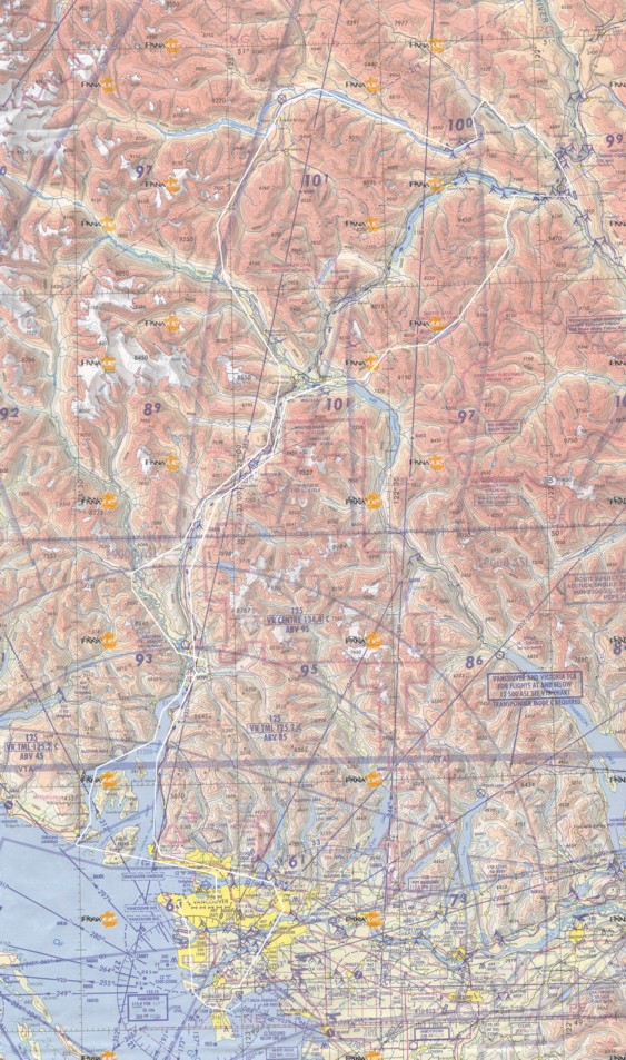
Here is a map of the route. Click here for a much larger detailed map.