Index of photo albums
-- randallg's homepage
-- Kat Kam
If you got here from a search engine and you do not see the photo index frame on the left,
click here
.
Comments and questions to randallg@telemark.net
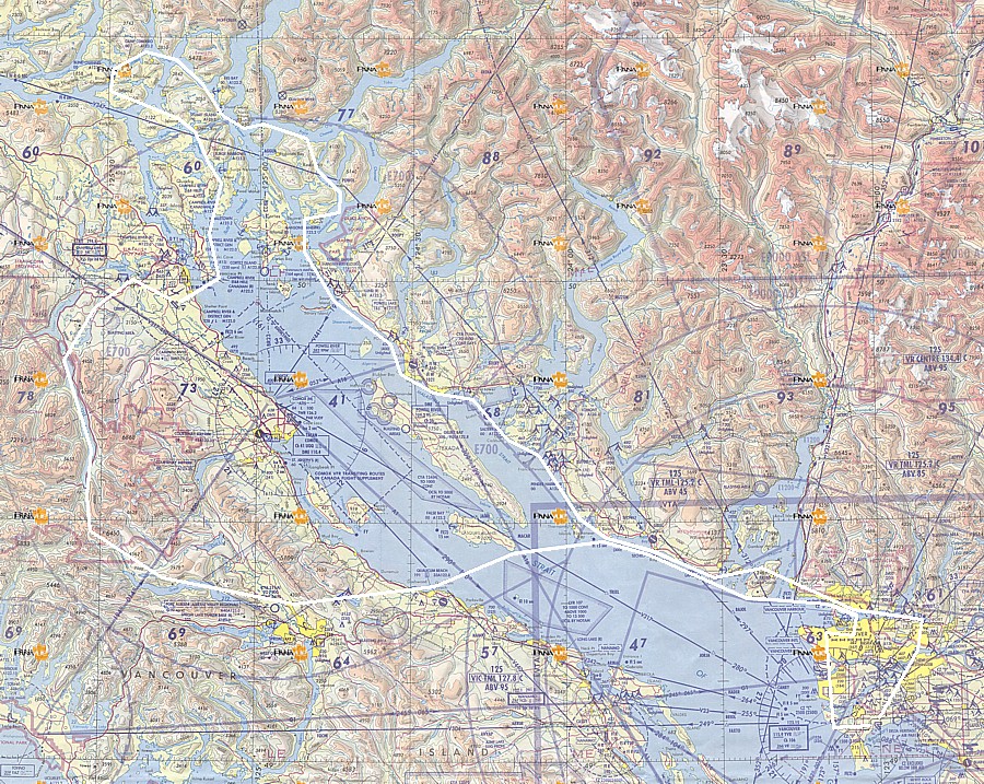
This is a photo essay of a flight from Boundary Bay, up the Sunshine Coast, around the Desolation Sound area, then to Campbell river for fuel and rest. Then into the heart of Strathcona Park, along Buttle Lake, past Della Falls, and back via Port Alberni, Qualicum Beach and Gibsons, ending with a cruise around downtown Vancouver and Stanley Park. A nice 4.6 hour trip in a Cessna 172.
001-004 A couple of warbirds on the ramp at Boundary Bay
- 001 - Boundary Bay warbird on the ramp
- 002 - Boundary Bay warbird on the ramp
- 003 - Boundary Bay warbird on the ramp
- 004 - Boundary Bay warbird on the ramp
005 Alex Fraser Bridge
- 005 - Alex Fraser Bridge
006 East over Fraser River, Port Mann Bridge
- 006 - Port Mann Bridge
007-009 East over Coquitlam
010 Indian Arm and Bedwell Bay
011-013 Deep Cove
014-019 Heading west along the north shore of Burrard Inet
020-021 North over Howe Sound. From here to Campbell River we are cruising at around 3000'
022 Bowen Island
023-024 Gambier Island
025 Keats Island
026-027 Gibsons
028-030 Roberts Creek
031-036 North over Wilson Creek - you can see Sechelt airport up the hill
037 Sechelt
038-043 Northwest from Sechelt to Halfmoon Bay
044-047 Pender Harbour
048-058 Nelson Island to Powell River - pix 057 shows Powell River airport
059-066 Proceeding northwest to Bliss Landing - views of Savary Island and pix 063 shows Lund
067-070 Entering the Desolation Sound. Circling views of Refuge Cove marina on West Redonda Island
071-074 Over Desolation Sound viewing Prideaux Haven to the east. This is one of the most popular anchorages for sailors in the area. Homfray Channel with steep sides rising to 6000'
075 Proceeding north up Waddington Channel between the two Redonda Islands. View eastwards up Pendrell Sound
076-081 North end of Waddington Channel to where it joins Pryce Channel and Toba Inlet. There are a couple of closeups of Walsh Cove where the oysters are the size of grapefruits
082-084 We turn west to follow Pryce Channel then past Raza Island
085-087 Looking south over the north end of Cortes Island
088-094 Turning north towards Stuart Island and Big Bay, at the Yuculta Rapids. 089 is a view west over Hole-In-The-Wall
095-103 Proceeding northwest then southwest up Cardero Channel to Blind Bay, with views of Phillips Arm. 103 is a closeup of the marina at Blind Channel. This is as far as we go and now we turn southwards and head for landing in Campbell River
104-109 Southeast to Okisollo Channel and the Octopus Islands. They are a lovely anchorage for sailors
110-113 South along the east shore of Quadra Island to Rebecca Spit
114-119 Turn west at Cape Mudge for approach and landing at Campbell River
120-122 After fuel and a brief rest, we take off and head northwest towards Campbell Lake
123-126 Upper Campbell Lake. There is some broken cumulus but we are able to stay clear of it as we head towards Buttle Lake. From here to the Alberni Valley we are at 7000 to 8000 ft or so
127-148 South above Buttle Lake with views to the west and east. You can see the mine at the south end of the lake
149-162 We follow a route from Buttle Lake to Great Central Lake which will take us past Della Falls The falls are the highest in Canada at about 1400 feet. They are still mostly frozen and can be seen in the centre of pix 155-158
163-165 Over Great Central Lake looking south over the ridge that separates it from Sproat Lake. The road to Tofino runs along Sproat Lake. Pix 164 is southwest towards one of the impressive structures on the route to Tofino
166-170 Over the upper Alberni Valley looking south. The town is in the distance and the airport is in the foreground
171-174 Over Horne Lake, past Mt Arrowsmith to Qualicum Beach. You can see the airport south of the town
175-177 Looking north over Bowen Island
178 Cruise ship leaving Vancouver Harbor for Alaska
179-197 We proceed in a big circle around downtown Vancouver at 3500' and get lots of good shots
198-201 Turning south for Boundary Bay, looking west over Point Grey, then east over Richmond
Here is a map of the route. Click here for a much larger detailed map.