Index of photo albums
-- randallg's homepage
-- Kat Kam
If you got here from a search engine and you do not see the photo index frame on the left,
click here
.
Comments and questions to randallg@telemark.net
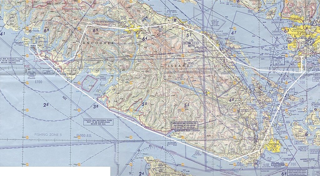
From Boundary Bay airport, direct to Tofino, and back along the southeast shore of Vancouver Island. We landed in Tofino and poked around for a few minutes. Due to lack of time we were not able to make the short walk to the ocean at the north end of Long Beach. There isn't much at the airport - a couple of mechanics were working on a Tofino Air Beaver on floats - they trucked it to the airport from the water. They have 100LL fuel available and since I parked near the pump, the fuel lady (who also does the weather reporting) came cycling over to help us. I had to apologize and say sorry we didn't actually need fuel. Apparently the golf course clubhouse, on the west side of the airport, is a more interesting place to stop so we will do that next time. Total Hobbs time was 3.5.
001-013 Boundary Bay to Nanaimo
- 001 - Point Roberts
- 002 - Point Roberts
- 003 - Back towards Vancouver
- 004 - Thetis Island
- 007 - Gabriola Island
- 008 - Nanaimo
- 013 - Nanaimo
014-025 Lantzville to Parksville
- 014 - Lantzville
- 015 - Nanoose Bay
026-045 Vicinity of Mt Arrowsmith and Horn Lake
- 026 - Mt Arrowsmith
- 032 - Horn Lake
- 033 - Mt Arrowsmith
- 041 - Horn Lake
- 042 - Sproat Lake
- 043 - Mt Arrowsmith
046-084 From Sproat Lake, following Highway 4 to the coast at Long Beach
- 046 - Sproat Lake
- 048 - Between Sproat Lake and the Pacific
085-101 Up the coast from Long Beach to Tofino
- 085 - Pacific Rim - Long Beach
- 099 - Wickaninnish Inn
- 101 - Tofino
102-108 Heading Southeast along the Coast from Tofino to Victoria
- 106 - Carmanah Beach and Lighthouse
- 108 - Victoria
109-114 From Victoria back to Boundary Bay
- 109 - Saanich Inlet
- 111 - Point Roberts
- 112 - Boundary Bay
- 114 - The Trusty Steed
Here is a map of the route. Click here for a much larger detailed map.